As we resumed our journey Deepak continued giving directions. I had a feeling we had missed a turn and heading in the wrong direction. We got the directions from few villagers, reached Tholapalli and finally GNKote was in our sights. Couple of kilometers before Gummanayakanapalya, we saw ruins of an ancient temple and a stepped well. This reminded me of the stepped well at Hampi. Later I learn little about Gummanayakana Palya's history and it's connection with Vijayanagara empire.

We climbed down and explored the ruins. As you this historic well isn't being cared for. A farmer was cutting grass for his cattle ...if not for farmers probably this well would have been swamped with all kinds of plants.

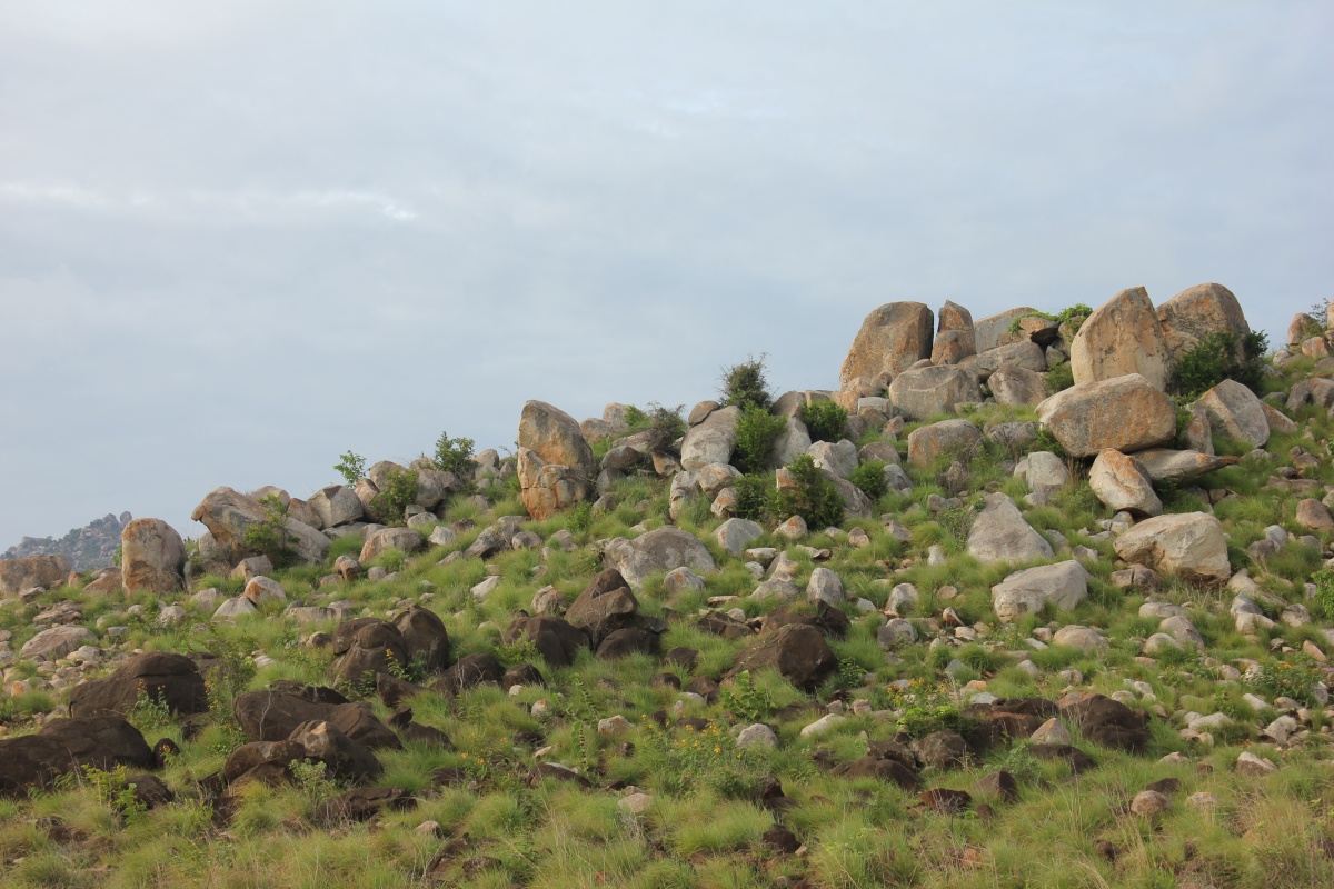
A standing boulder caught my attention. You can see Gummanayakana Kote in the background.

At the village square we found a group of people sitting idle. I inquired if we can get a guide to take us up the hill and show the fort. Raghunatha Reddy came forward to help us and asked couple of teenage boys, some how they weren't interested. Raghunath showed us the way till the fort's main entrance. During the short walk, he mentioned that cattle herding is the main profession and source of income for people here. The narrow village lane we walked through was littered with sheep droppings. Agriculture is secondary but unprofitable. Farmers' plight is same :( where ever I've been until now.

We pass by temples dedicated to Ganesha and Hanuman.

The second gateway is like a security office with halls on either sides. Probably it also served as a waiting lounge for visitors.

The fort with seven rings of walls.

I was delighted to see this structure, ruins of a palace. Going by the looks it could be a much recent construction. We could go up the steps and see the inside of the balcony.

The arched floral window with grills were interesting and preserved quite well until now but you can see acts of vandalism. When will people learn to respect historical monuments?

Another gateway through thick walls. The path has a ninety degree turn right, a security feature fort designers had adopted.

As we walk between the walls, we come to another security office we passed through earlier but much smaller. Right next to the walls was this stone which I assumed was a Shiva Linga. On the Linga shaped stone has a Shankha and a Chakra, symbols of Vishnu.

Puddles of water and overgrown thorny shrubs had hidden the path on our left. I went up a rock exploring a path towards the temple but it was too steep for mom. Durga and mom decide to settle on a rock nearby while Deepak and Gulli join me.

While trying to locate the upward path, I find the path which mom could have easily climbed. I go down and ask the ladies to come up but mom was busy with Sudha and refused to move. Aagh! I started climbing back again.
That's the gateway to the core of the fort, the summit.

There's nothing much inside, I mean no major constructions like guard rooms or offices or temples. The hill top provides a good view of the surrounding village below, the plains, hills and lakes.

Rampart wall and bastion as seen from another bastion. I had to crouch to pass through an opening barely wide enough and half my height to reach the bastion I was standing on.

On to the left, more walls and bastions. Notice the rock formation to the extreme right?

This rock formations defines the skyline of Gummanayakane Kote. I wonder if the two rocks fitting each other is a natural creation or man made.

Some parts of the fort has natural defenses but walls have been built to ensure safety.

Rain water harvesting pond featuring both natural and man made characteristics.

Perhaps this two level open area was for soldiers to train and practice weaponry skills.

As seen from the lower level facing the opposite direction.

We walk along the wall with a sheer drop. Notice ruins of a small house like structure. This is the only constructions here and seems like from the same time as the palace below.

The position of the well is very interesting. Deepak and Gulli had missed seeing this and were chatting away near the gateway while waiting for me to join them. I said this could be a good place to punish criminals by pushing them down into the well. Deepak had different thoughts; he said this could be an emergency escape point. We jokingly discussed the plight of a criminal thrown down, Deepak said he might just come back and say "Sir, I enjoyed the dive, why don't you throw me down again!?"

We came down, on the way to the well, which is a stone's throw behind us, we found this left-over of probably a huge tree. Gulli posed as though he discovered a dinosaur skeleton :) Gulli keeps us smiling even though he's sad inside.

Looking up towards the summit.

Black coating on Rock face ..what could that be? Has it got anything to do with the color of the water in the well?

Water looks sinister. We felt the water could be clean ...good enough for bathing and washing. Of course back then, this would been an important source of water and maintenance activities like adding lime would be done on a regular basis.

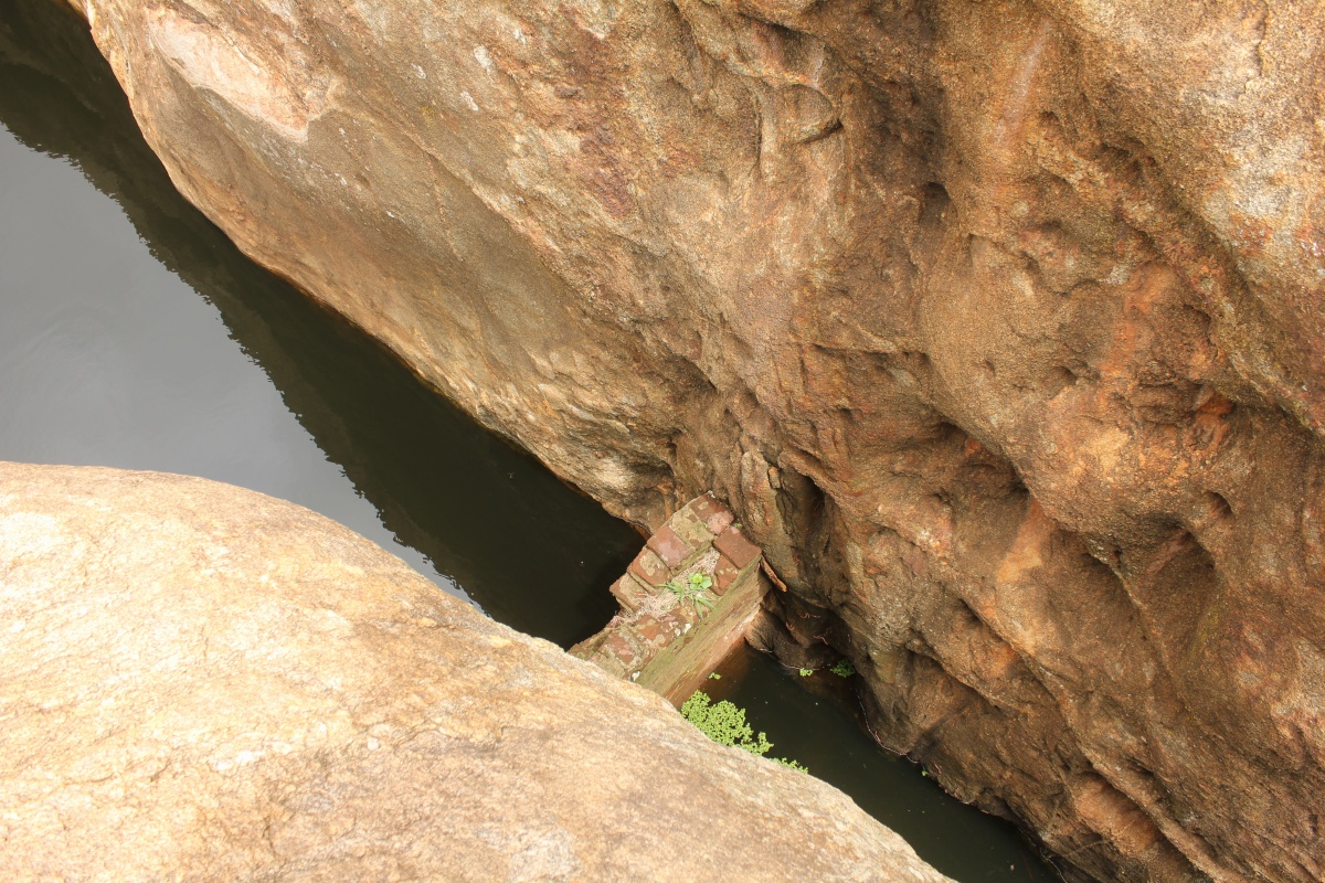
The chasm between these massive rocks form a natural outlet for the water. However, a brick wall built across the walls works like a dam.
An ancient structure which could have been a granary.

We go down the hill and reach the other inner palace ruins close to where Durga and mom were.

All of us liked the place, in fact we spoke about camping one night at the summit. It was past noon when reached the village square.
Link to videos shot at Gummanayakana Kote.
Gummanayakana Kote co-ordinates; 13°48'8"N 77°55'34"E
.........